Our Assets
Mt Magnet Hub
Located adjacent to the town of Mt Magnet, around 500 kilometres north-east of Perth in Western Australia’s Murchison Goldfield, the Mt Magnet Hub is Ramelius’ cornerstone production centre and a key driver of its 5-Year Growth Pathway.
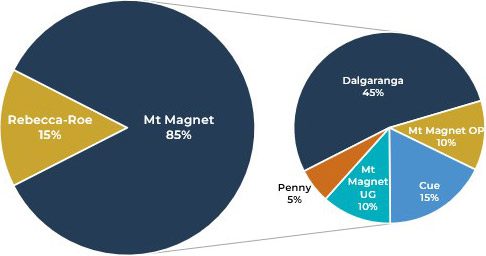
The hub includes open pit operations at Mt Magnet and Cue, underground mines at Mt Magnet, Dalgaranga and Penny, and a central processing plant that supports the wider regional mining portfolio.
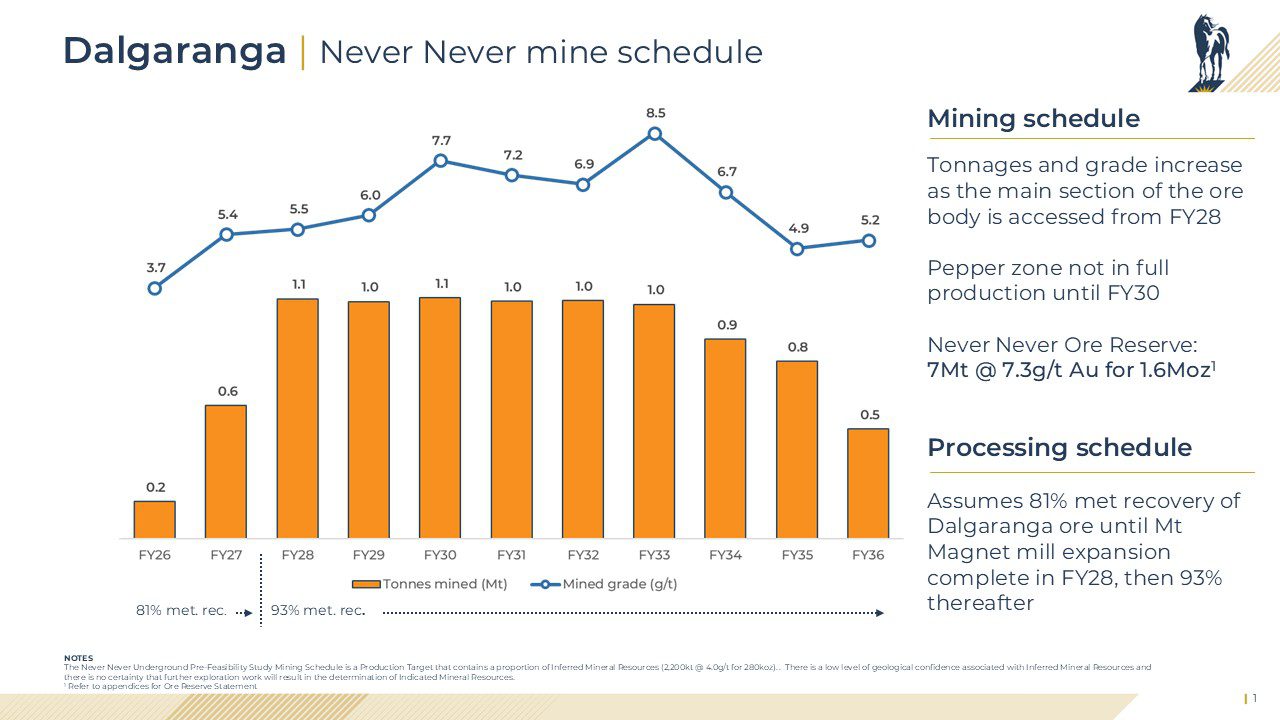
Dalgaranga is one of the highest-grade gold projects in Australia, with the Never Never underground deposit hosting a maiden Ore Reserve of 7.0Mt at 7.3g/t Au for 1.6Moz and providing a significant source of future high-grade ore for the hub.
Ore from Dalgaranga, Penny and Cue is transported by road train to the Mt Magnet processing plant, creating an integrated hub model designed to improve scale, flexibility and operating efficiency.
With the planned expansion of the Mt Magnet processing plant to support a preferred single-site processing option of up to 5Mtpa, the hub is expected to deliver approximately 350,000 ounces per year by FY30, reinforcing its role as a long-term, low-cost production centre.
Once complete, Mt Magnet is expected to be:
- A Tier 1 production hub on both production scale and cost metrics
- A long-term production rate of approximately 360koz per annum
- A$1,885/oz AISC average over the next 5 years to FY30

Group 5-Year gold production
Production from FY26 to FY28 will be solely sourced from the Mt Magnet Hub
Operating Mines
- Mt Magnet
- Dalgaranga
- Penny
- Cue
Mining Methods
- Underground
- Open pit
Processing
- Mt Magnet processing plant (1.9Mtpa)
Total 2025 Resources and Reserves
- Mineral Resources 114Mt at 2.1g/t for 7.9Moz
- Ore Reserve 44Mt at 2.2/t for 3.1Moz
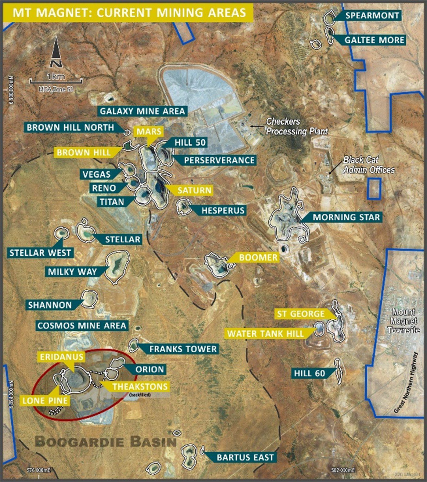
Mt Magnet Production Hub
Ramelius acquired Mt Magnet Gold Pty Ltd from Harmony Gold in 2010 and restarted operations in late 2011.
Since then, the Mt Magnet production hub has grown into a significant regional production centre, incorporating the Eridanus and Cue open pits, Galaxy underground mine at Mt Magnet, the Never Never underground mine at Dalgaranga and the Penny underground mine. Together, these assets form an integrated mining hub centred on the Mt Magnet processing plant.
With a strong resource base, a growing pipeline of high-quality ore sources and ongoing exploration upside, Mt Magnet is positioned to become one of Australia’s leading gold production hubs.
Key facts
Ownership
100%Status
ProductionMining Method
Underground and open pitProcess Method
1.9 Mtpa processing plant, upgrade to 4.3Mtpa underway(optional up to 5.0Mtpa)
Mineral Resources
82Mt @ 1.6g/t for 4.2Moz (as at 30 June 2025)Ore Reserves
33Mt @ 1.1g/t for 1.2Moz (as at 30 June 2025)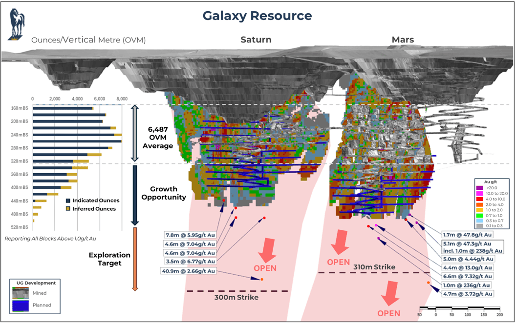

Mt Magnet Exploration
Ramelius will continue to increase the Mt Magnet hub's production with a focused exploration program targeting key growth areas. Work will initially concentrate on ongoing drilling across the Penny, Cue and Galaxy mining areas, then subsequently expand efforts into new underground zones such as Gilbeys (West Winds, Four Pillars and Applewood), alongside surface targets including Sly Fox, Plymouth and the Never Never–Golden Wings trend. These exploration activities support Ramelius’ broader strategy to unlock new resources, extend mine life and enhance the long‑term operational performance of the Mt Magnet operation.
Mt Magnet Processing Plant
As part of Ramelius’ vision to become a 500,000 ounce per year gold producer by FY30, the Mt Magnet processing plant is central to that ambition, with the Mt Magnet Hub targeted to deliver 360,000 ounces of that annual production.
The Mt Magnet–Dalgaranga Integration Study, released in 2025, sets out the strategic business case for processing high-grade Dalgaranga ore through the Mt Magnet processing plant. To support this expanded production profile, Ramelius will invest A$223 million to increase mill throughput capacity to between 4.3Mtpa and 5Mtpa.
The expanded Mt Magnet plant will have two comminution circuits, both circuits planned to be operational in the September 2027 Quarter (Q1 FY28):
Circuit 1: Repurpose and refurbish the existing Mt Magnet 2Mtpa plant to 1.3Mtpa and reduce the grind size from 175µm (current) to a grind size of 53µm to obtain optimal recoveries from the Dalgaranga ore.
Circuit 2: Install a new 3Mtpa circuit at a grind size of 175µm to process Mt Magnet ore sources. This will include relocation and repurposing of existing equipment from the Dalgaranga plant.

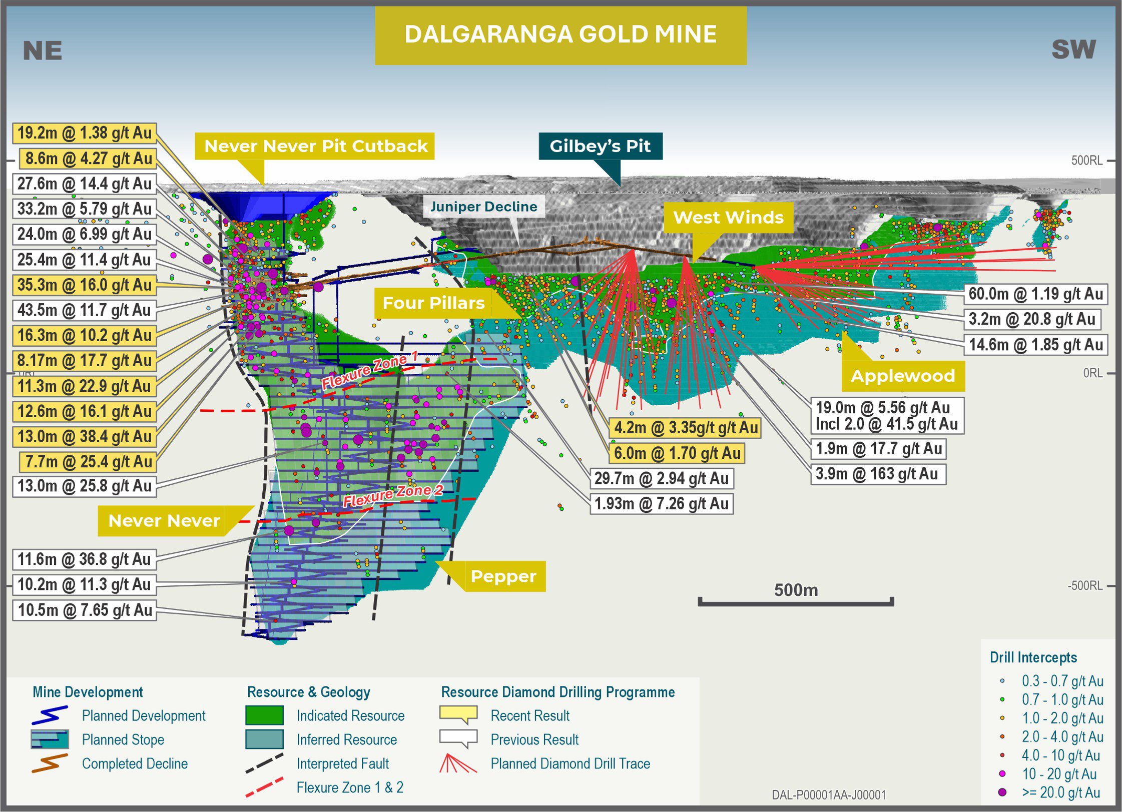
Dalgaranga
The Dalgaranga deposits were acquired by Ramelius through its merger with Spartan Resources in July 2025, adding significant Resources to the Company’s portfolio. The Dalgaranga portfolio includes Never Never, Gilbeys, Plymouth, Sly Fox and Archie Rose deposits.
Gold mineralisation at Dalgaranga is predominantly associated with shear zones within altered schist sequences, characterised by biotite-sericite carbonate and pyrite alteration with quartz-carbonate veining. These shears are hosted within a volcaniclastic-shale-mafic rock package, comprising dolerite, gabbro and basalt lithologies.
The Never Never deposit, one of the key assets within the Dalgaranga portfolio, is situated at the northerly extension of the Gilbeys main zone. The mineralised zone strikes northeast–southwest and dips moderately to the northwest.
Key facts
Ownership
100%Status
ProductionCurrent Mine Life
10 yearsMining Method
Open pit and undergroundMineral Resources
16Mt @ 5.1g/t for 2.6Moz (as at 30 June 2025)Ore Reserves
7Mt @ 7.3g/t for 1.6Moz (as at 28 October 2025)Processing
Ore from Dalgaranga is trucked to our processing facility at Mt Magnet. First ore from Never Never was trucked to Mt Magnet in February 2026.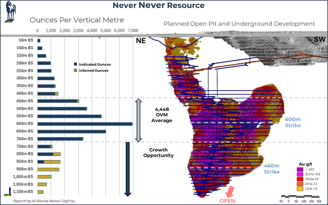

Dalgaranga Exploration
A spend of A$15-19M is planned in FY26 on studies and exploration programs, focusing on a drill program of up to 75,000 metres targeting West Winds, Four Pillars and Applewood to expand on the existing Gilbeys underground resource.
Cue
Located in the Murchison region of Western Australia, the Cue project comprises eight satellite gold deposits including Break of Day, White Heat, Lena, Waratah, Amarillo, Leviticus, Big Sky and Numbers.
Situated predominantly between the townsites of Mount Magnet and Cue, and approximately 40 kilometres north of the Mt Magnet Processing Plant, Cue benefits from its proximity to established processing infrastructure.
Gold mineralisation at Cue is hosted within classic Archean-aged greenstone sequences, characteristic of the highly prospective Murchison region, one of Western Australia’s most enduring and productive gold terranes.
Key facts
Ownership
100%Status
ProductionCurrent Mine Life
5-YearsMining Method
Underground and open pitMineral Resources
11Mt @ 2.1g/t for 740Koz (as at 30 June 2025)Ore Reserves
3.8Mt @ 2.0g/t for 250Koz (as at 30 June 2025)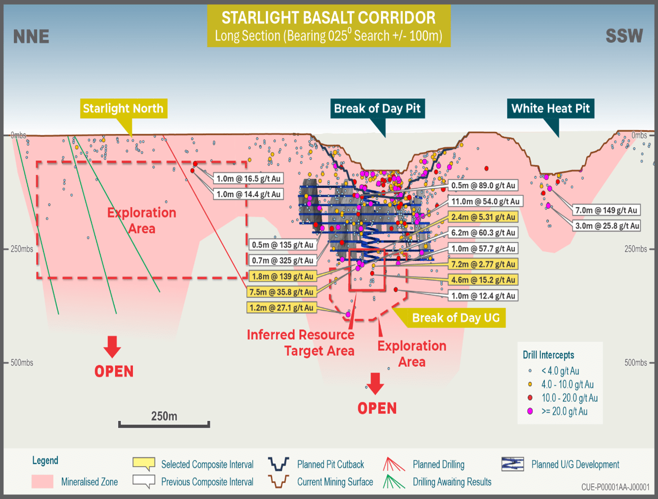

Cue Exploration
An exploration spend of A$13-16M is planned in FY26 with a primary focus on extending known high-grade underground deposits.
Fast track to production
Acquired in 2023, Cue is a demonstration of our ability to fast-track assets to development and production. For Cue, we realised return on investment of $206M purchase payback and capital development costs in just nine months of production.
We initiated mining on Break of Day in August 2024, with mining for FY25 totalling 521kt at 6.82g/t and processing totalling 295kt at 10.66g/t for recovered gold of 98koz.
This work has delivered a 136% growth of the predicted grade and 136% of the predicted ounces from the original resource modelling.
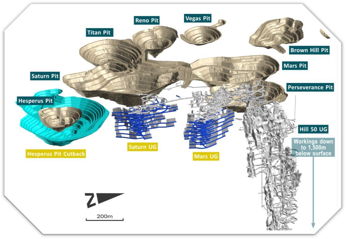
Galaxy
The Galaxy underground mine, comprising the Mars and Saturn gold deposits, represents a key cornerstone of Ramelius’ current mining operations at Mt Magnet. All deposits sit within a contiguous tenement holding, located within an eight kilometre radius of the Mt Magnet processing facility, providing a significant logistical advantage and supporting efficient, low-cost ore delivery to the processing plant.
The higher gold prices of the 1980s saw several large open pits developed across the Galaxy mining area, including the Mars and Saturn pits. Ramelius subsequently mined the Galaxy open pits from 2012 to 2018 before transitioning to underground operations, with the Galaxy underground mine now serving as the primary source of ore at Mt Magnet.
Geological interpretations suggest the two dominant mineralised bars, Saturn and Hill 50, are isoclinally folded equivalents, based on the mapped distribution of hanging wall and footwall mafic and ultramafic units within the Mars, Saturn and Perseverance pits. In the footwall of the Sirdar Formation, the Boogardie Basin is dominated by talc-carbonate altered ultramafic sequences and peridotitic sills, intruded by domal felsic dacite to rhyolitic porphyry bodies.
Key facts
Ownership
100%Status
ProductionCurrent Mine Life
2 yearsMining Method
UndergroundMineral Resources
6.2Mt at 2.7g/t for 530Koz (as at 30 June 2025)Ore Reserves
1.9Mt at 2.6g/t for 160Koz (as at 30 June 2025)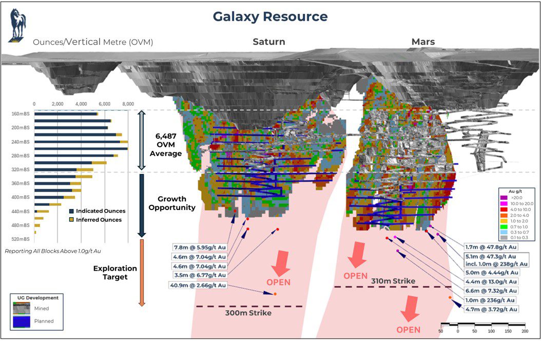

Penny
Located approximately 150 kilometres south-east of the Mt Magnet operations and around 550 kilometres north-east of Perth, the Penny Gold Mine is one of Ramelius’ highest-grade assets, with ore hauled along existing access roads to the Mt Magnet processing plant.
The Penny North underground operation utilises conventional small-scale mechanised development and stoping methods, with longhole drilling and blasting of up-hole bench stopes underway, in combination with in-situ pillars and cement rock fill stope support.
Penny continues to be an active focus for exploration, with ongoing drilling targeting strike and depth extensions to the known resource area.
The Penny West deposit was first discovered in 1990 and mined as a high-grade open pit in 1990/91, producing approximately 154,000t at 18.0g/t Au for 89,000oz. Following a period of limited activity, Spectrum Metals discovered the Penny North lode zone in March 2019, and Ramelius acquired the project in 2020 through an off-market takeover offer of Spectrum Metals Limited.
Gold mineralisation is hosted within large quartz-sulphide lode veins occurring within a steeply dipping greenstone stratigraphy dominated by mafic and ultramafic units, with minor felsic and granitoid intrusive units. Overall, mineralisation at Penny is controlled by a northerly trending structural corridor known as the Penny Shear Zone.
Key facts
Ownership
100%Status
ProductionMining Method
UndergroundMineral Resources
2.1Mt at 16.4g/t for 110Koz (as at 30 June 2025)Ore Reserves
2.6Mt at 8g/t for 71Koz (as at 30 June 2025)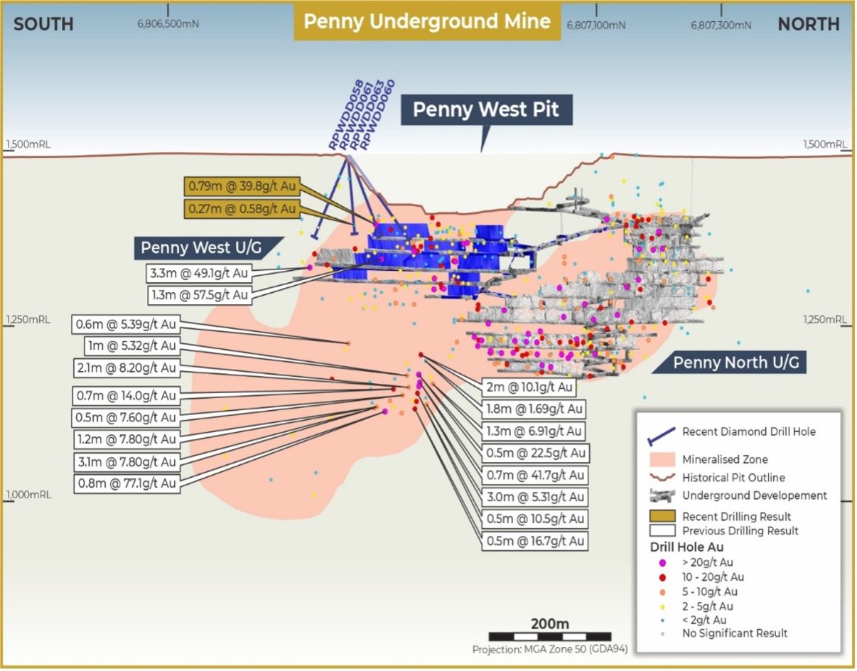

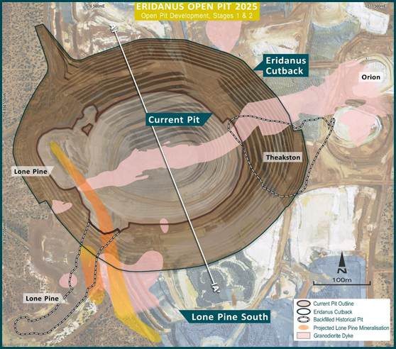
Eridanus
Discovered by Ramelius in late 2017, Eridanus has grown from an early-stage open pit into one of the most significant deposits in the Mt Magnet hub.
Mining of the Stage 1 pit commenced in mid-2019, with ongoing drilling success and significant resource growth prompting the development of a larger Stage 2 pit, which commenced in June 2020 and was designed to reach a depth of 235 metres below surface.
Mineralisation at Eridanus occurs as stockwork veins concentrated within the east-west orientated Eridanus Granodiorite, which has intruded into felsic aphyric to porphyritic intrusive rocks. This style of large-scale, bulk-tonnage mineralisation distinguishes Eridanus from the higher-grade lode deposits elsewhere in the Mt Magnet field and underpins its potential as a major, long-life source.
Key facts
Ownership
100%Status
ProductionCurrent Mine Life
6 yearsMining Method
UndergroundMineral Resources
24Mt at 1.7g/t for 1.3Moz (as at 30 June 2025)Ore Reserves
18Mt at 1.2g/t for 680Koz (as at 30 June 2025)
