Edna May Gold Exploration Projects
Location and Access
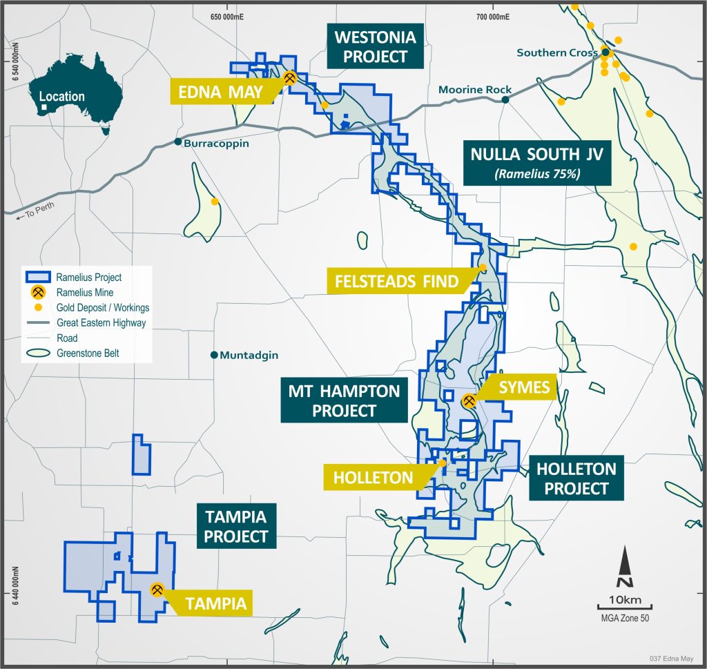
The Edna May Gold Mine is located 300km east of Perth. It abuts the township of Westonia, in the heart of the Western Australian Wheatbelt. Westonia is situated 10km north of the Gt Eastern Highway, half way between Perth and Kalgoorlie.
Background
Ramelius has successfully consolidated a significant exploration land package around the Edna May gold mine, since acquiring the mine in October 2017. Ramelius is now the dominant land holder throughout the Westonia and Holleton greenstone belts. Ramelius has acquired tenements outright plus entered into two farm-in and joint venture agreements with Chalice Gold Mines (ASX: CHN) subsidiary, CGM (Australia) Pty Ltd, to earn a 75% interest in both the projects by spending $2 million on each project within 3 years.
Geology and Mineralisation
The geology of the Westonia greenstone belt is interpreted from available aeromagnetic data and historical RAB/Aircore drilling as the belt is only poorly exposed. The belt is dominated by a narrow west-northwest trending sequence of sheared north dipping mafic amphibolites, tremolite chlorite rich ultramafics and sedimentary (paragneiss) plus granitic gneissic (orthogneiss) rocks.
Faulting has disrupted and repeated the stratigraphy, resulting in duplexing and structural thickening of units. Multiple phases of granite magmatism have occurred within the belt, including domal uplifts of internal granitoids, resulting in the greenstone stratigraphy wrapping around the domes as well as obvious late, post deformational intrusions.
A structural history of the belt was postulated by various workers including Etheridge, Henley and Williams (circa 1996) (1). Their synopsis is presented in Table 1 below. The stratigraphy is interpreted to include a lower unit of felsic gneiss (metasedimentary rocks), a middle mafic amphibolites to ultramafic unit (magnetic) and an upper sedimentary unit. The Edna May orthogneiss intrudes along the contact between the footwall amphibolites and the hangingwall ultramafic rocks.
Table 1: Structural Synthesis of the Westonia Belt – after Etheridge, Henley and Williams (1)
| Event | Structure | Example | Effect |
| D-5 | NNE faults | cut all older structures and granitoids | Dextral fault offsets |
| Granite magmatism | Ag-5 – undeformed plutons | undeformed plutons | |
| D-4 | NW-SE thrust faults | throughout Westonia Belt | Faults cut D-2 thrusts and Ag-3 granites |
| D-3 | Upright folding? | uncertain | Variations in dip, steepening of D-2 thrust faults |
| Granite magmatism | Ag-3 – foliated adamellite | Cut D-2 thrusts and cut by D-4 faults | |
| D-2 | NW-SE thrust faults | throughout Westonia Belt | Regional thrust stacking |
| D-1 | Granite emplacement | Ag-1 – foliated adamellite | Possible dome formation |
The belt is intensely deformed and attenuated with a strong north-west trending fabric represented by D-2 NW-trending thrust faults and folds. As compression continued, these faults became folded into a synclinal structure and were cut by a series of steep reverse faults during D-4 deformation. Gold mineralisation is interpreted to be late, and coeval with the D-4 deformation.
The Edna May Gneiss manifests as a mylonitised biotite gneiss that hosts the auriferous quartz reefs seen in the mine. They are interpreted as late syn-kinematic veins (after Etheridge Henley and Williams, 1996). An overall sinistral movement across the belt can be invoked from the regional aeromagnetic interpretations and for the interpretation of the high grade veins (Jonathon and Fuji) within the Edna May Gneiss. Although the gneiss has been mylonitised, this deformation was early and during the mineralising event the gneiss appears to have acted as a more competent body in a major shear zone.
The Edna May reefs appear to be the product of dilation associated with the left stepping bend mapped in the pit. The series of reef propagating from the footwall contact of the gneiss have been produced during the sinistral movement by the progressive development of tension gashes during deformation. The reefs pitch @ 45 degrees to the movement direction during vein formation, that is they pitch to the north-west. This suggests a component of thrust movement on the gneiss margins during mineralisation. Litho-structural interrogation and modelling is ongoing to fully understand the controls on gold mineralisation at Edna May.
Several small historical gold occurrences exist throughout the larger Westonia EL, in rocks variously described as Edna May Gneiss equivalents to attest to finding more significant gold mineralisation along strike of the mine.
Table 2: Summary of historical gold production within the Westonia EL (away from the Edna May Mine) (2)
| Mine Area | Tonnes Mined | Gold Produced | Average Grade | Host Geology |
| Princess Royal | 20,700 tonnes | 13,900oz Au | 20.9 g/t Au | Edna May Gneiss |
| Battler | 2,153.5 tonnes | 2,148.86oz Au | 31.0g/t Au | Edna May Gneiss |
| Hillend | 194 tonnes | 136.87oz Au | 21.94g/t Au | Edna May Gneiss |
| Pertha | 392 tonnes | 263.41oz Au | 20.9g/ Au | Qtz-diopside veins |
| Weston’s Reward | 508.5 tonnes | 481.9oz Au | 29.5g/t Au | Qtz veins |
| Le Trois | 1,680 tonnes | 1,032oz Au | 19.1g/t Au | Bio alt amphibolite |
| Rutherfords Find | 250,000 tonnes | 7,234oz Au | 0.9g/t Au | Laterite cap |
| Comstock | unknown | unknown | unknown | Edna May Gneiss |
| Collossus | unknown | unknown | unknown | Edna May Gneiss |
Detailed airborne aeromagnetic surveys have mapped a continuum of the greenstone stratigraphy, linking the greenstone rocks within the Nulla South JV with those at Holleton. The greenstone belt swings southwards at Felstead’s Find.
Historical mining activities at Felstead’s Find consist of two shallow shafts. Only limited historical RAB/AC and RC drilling has been conducted around the workings, in areas of soil anomalism and along regional traverses across parts of the greenstone belt. Gold mineralisation (up to 7.40 g/t Au) is reported in the northern shaft. The gold occurs in quartz veins and ferruginous shear zones near a contact between sediments and gneissic rocks. Quartz veining is parallel to the apparent NW trending foliation. Gold mineralisation (up to 3.40 g/t Au) is reported in the southern shaft and it occurs within quartz veining. The orientation of veining and foliation appears more E-W and reflects the overall folding of the stratigraphy as observed in the aeromagnetic data.
Outcrop throughout the Holleton Greenstone Belt is poor such the geology is only interpreted from available aeromagnetic data and limited historical RAB/Aircore drilling, where available. Ramelius has completed a preliminary aeromagnetic interpretation of the available data. Observations from this interpretation are summarised below.
The Holleton belt comprises mapped mafic volcanic or intrusive lithologies and amphibolites, with some metasediments including graphitic schists. Drilling has identified a prominent ultramafic unit (Mt Hampton Ultramafic) along the east side of the belt. Along the eastern margin of the belt (and often along the east side of the ultramafic unit) various biotite gneisses are mapped, with the notation in GSWA logging that these may be after felsic volcanics.
The stratigraphy strikes north-south through the northern two thirds of the Holleton belt, but swings into a westerly strike on the southern end of the belt where it passes through the historical Holleton Mining Centre.
Known mineralisation within the Holleton belt is restricted to historical gold mining at Holleton, encompassing the Calzoni, Columbus and Brahma Trends discussed in more detail below.
Brahma Trend
This trend is 2.5km long (Figure 4), with a 150m wide >50ppb gold in soil anomaly representing the main target. Residual regolith profiles dominate over the anomaly with transported cover appearing to limit the strike extent. Previous explorers conducted Aircore drilling along the extent of the anomaly with anomalous gold and arsenic values intersected in several holes. Three diamond drill holes were completed, with all intersecting broad zones of anomalous mineralisation (best results include 73m at 0.30 g/t Au, including 4m at 1.60 g/t Au and 1m @ 7.60 g/t Au). Mineralisation is hosted by fine to medium grained amphibolites.
Calzoni Trend
The Calzoni target was identified from intersections in diamond drilling conducted by Valiant Resources during the 1980’s (up to 6m @ 6.70g/t Au). The Calzoni area (historical Holleton Mining Centre) contains shallow historical workings, including a small pit and numerous shafts from which 14,000oz of gold was reportedly produced up until the 1940’s. Detailed mapping of the area was completed by Perilya and has been captured in their open file reports. Regolith cover over the Calzoni Pit ranges from approximately 0.2 – 1m in thickness and is dominated by soil and calcrete of likely residual origin. Mapping of the pit indicates a biotite-amphibole-quartz schist host rock with lozenges of quartz + diopside + microcline + sulphide alteration. Sulphide assemblages are dominated by pyrrhotite, with minor pyrite, arsenopyrite and chalcopyrite, and several mentions of free gold in the drill core logs. Encouragingly, the rock units and alteration assemblage appears analogous to the granulite facies rocks reported at Tampia Hill.
Historical rock-chip sampling from the pit reportedly obtained results of 28m at 3.60 g/t Au around the pit wall and 6m @ 12.0 g/t Au in the historical stopes, indicating mineralisation is not restricted to observed narrow quartz veins.
Columbus Trend
Surface soil sampling identified a 2.5km x 150m zone of east-west trending >200ppb gold anomalism. Subsequent RAB drilling on 320m and 160m spaced traverses intersected significant zones of mineralisation, including 27m at 1.05 g/t Au from 19m in HRB272, 11m at 1.25 g/t Au from 25m in HRB12, 10m at 1.73 g/t Au from 26m in HRB42. The drilling identified a 10-40m wide shear zone (Rubicon Shear) at the contact between a dolerite and sedimentary unit, with calc-silicate, sericite and sulphide alteration.
- Etheridge Henley and Williams (1996); Kinematic history and controls on mineralisation in the Southern Cross and Westonia greenstone belts. Equinox Resources NL (unpublished Company Report).
- Brand M.J, & Bateman L.P., 1997; Westonia Joint Venture Annual Report for the period ending 1 March 1997. Equinox Resources NL, WAMEX Open File A51029.